|
|
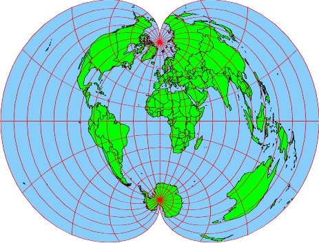
| Figure 1. The Polyconic Projection. This map's central meridian runs along the prime meridian. |
The origins of the polyconic projection are a little obscure, but most researchers credit Ferdinand Rudolph Hassler with developing the first comprehensive description of this projection around 1820. Hassler was a Swiss scientist who became famous for conducting the first complete and accurate survey of the coast of the United States. He also founded what is now known as the U.S. Coast Survey Office, and in general instilled a tradition of scientific rigor into the U.S. government's efforts to measure quantities and conduct surveys.
The polyconic projection is neither
conformal
nor
equivalent;
it is a compromise projection that attempts to minimize all distortions
while not eliminating any particular type of distortion. It was an
extremely popular projection from the mid 1800s through the mid 1900s;
its popularity has waned in the last 50 years. This loss in popularity
is vividly demonstrated by how the polyconic projection has been handled
by the U.S. Geological Survey. From 1886 through approximately 1957, the
USGS used the polyconic projection as its standard for the production of
all of its 7½ minute quad maps. However, since 1957, new quad maps
have used the
Lambert projection
instead (Note that since 1957, many 7½ minute quads incorrectly
state that they were produced using a polyconic projection; someday
the USGS will get it right).
| 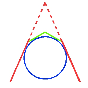
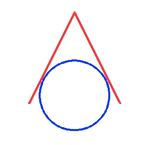
| ||||
| Figure 2. A classic tangent, conic projection with the cone-shaped developable surface (in red) draped over the model of the Earth (in blue). | Figure 3. A multiconic projection with a
developable surface
made up of two cones. In this case, both cones (shown in red and green)
have their apexes above the North Pole of the
model of the Earth.
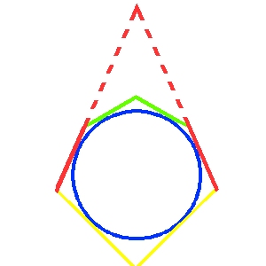
Figure 4. A multiconic projection with a
developable surface
made up of three cones. In this case, two cones (shown in red and green)
have their apexes above the North Pole and the third cone (shown in yellow) has
its apex over the South Pole of the
model of the Earth.
| | |||
A true polyconic projection carries this idea to the extreme, and has an infinite number of cones draped over the model of the Earth. Half of these cones have their apexes over the North Pole, and the other half have their apexes over the South Pole. Thus, the form of the polyconic projection could accurately be described as involving an infinite number of cones, or a little less specifically, as involving many cones -- but that's exactly what polyconic means. Thus, the form of the polyconic projection is usually described as being "polyconic."