FROM RESEARCH TO DESIGN
re-engineering the space
of Trafalgar Square
Professor Bill
Hillier, Tim Stonor,
Mark David Major and Natasa Spende
September
1998
Introduction
The Space Syntax Laboratory UCL
is part of Sir Norman Foster's team carrying out the World Squares for All
project in the centre of London. It advises the team on pedestrian space
use and movement and spatial design. In this paper, we describe how the
Space Syntax team analysed and modelled the existing pattern of space use
and movement in and around Trafalgar Square, and from this evolved
proposals for design modifications which would lead to a richer pattern of
use there.
Aims of the Team in Trafalgar
Square
The aims of the team in Trafalgar Square have
been:
a. to make sure the space is accessible and intelligible to
all pedestrians, including people living and working in London, people
visiting the National Gallery, and tourist visitors
b. to make sure
that all the space in the Square is used to some degree, since large,
empty spaces always detract from the 'feelgood' factor in a public
square
c. to ensure everyday use of the Square throughout the year
by Londoners and visitors, as well as ensuring it is safe for special
occasions
d. to make sure there is enough space in the Square for
all those who would in future benefit from using it.
The
Current Pattern of Space use and Movement in the Square
As part
of its work on the World Squares for All Project, the Space Syntax
Laboratory has undertaken the most detailed survey ever of pedestrian
movement and space use in central London. The objective in making this
survey has been to establish the current pattern of pedestrian activity in
the study area, identify the specific problems faced by pedestrians and,
from this analysis, generate design ideas which address these problems and
satisfy the overall aims of the project.
In making the survey we
have sent teams of trained observers onto the streets of London. They have
counted leveles of pedestrian movement in over 300 locations at different
times of the day, on different days of the week, and in different seasons
of the year (Figure 1).
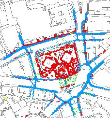

Figure 1 Pedestrian
Activity in Trafalgar Square
The results of our survey provide a
comprehensive picture of pedestrian activity and show that the key
features of space use in Trafalgar Square are:
a the heart of the
Square is used almost exclusively by visitors (the red dots in Figure
1)
visitors are concentrated mainly in the south-east corner of the
Square, leaving large, relatively empty areas to the north and
west
b there is virtually no movement across the heart of the
Square (the thin blue lines in Figure 1). Instead we see Londoners moving
around the outside pavements of the Square (with some movement across the
inside, southern pavement) and visitors meandering slowly within the
Square
c there is much 'informal' road crossing by visitors,
especially from the south side of Trafalgar Square in order to get to the
best views from the King Charles traffic island (the thick green lines in
Figure 1)
d there is almost no stationary use of the Square by
Londoners. Instead, most Londoners walk around the edges of the Square
than across it. In doing so they face major delays at pedestrian
crossings. Many cross 'illegally' when faced with the choice of
waiting
e the upper level space on the north side of the Square is
virtually unused, either for movement or stationary
activity.
Why the Square Works this Way
At first
sight, the main problem of Trafalgar Square appears to be that it is cut
off from its surroundings by dense traffic. In fact, this is only a part
of the story. Simply removing the traffic would not in itself lead to
significant improvements in pedestrian use. Space Syntax analysis of
Trafalgar Square shows that - while the effects of traffic are important -
they are not nearly as important as the influence of design.
Recent research has shown, and experience confirmed, that design
can make the difference between well and poorly used urban spaces, and
that design means first and foremost spatial design. Merely adding
landscaping and facilities to poorly designed spaces will not make those
spaces work. Good spatial design involves three key elements:
a.
simple, direct routes for pedestrian movement which pass through the
middle of the space and not just around its edges
b. positions
within the space from which people can see out in several directions, and
therefore understand the way in which the square fits into its wider urban
context
c. facilities for eating, drinking or resting which are
located close to - but not in the way of - the main pedestrian movement
routes.
Our analysis shows that each of these elements is missing
from the current design of Trafalgar Square. Instead, the current design
of the space is directly responsible for the uneven pattern of use which
we have observed. In particular:
a. detailed analysis of the visual
'fields' available from Trafalgar Square shows that the views available
from the geometric centre of the Square (Figure 2) are very constricted,
and nowhere near as strategic as those from the King Charles traffic
island (Figure 3). This is why visitors to London gravitate towards the
traffic island - dashing across the road with camera and guidebook in hand
- in order to gain their bearings and take photographs:
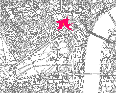
Figure 2 Visual Field
from Geometric Centre of Trafalgar Square
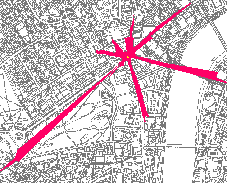
Figure 3 Visual Field
from King Charles Traffic Island
b. the existing stairs in the
north-west and north-east corners of the Square inhibit the kind of
criss-crossing movement through the body of the space which other studies
have shown to be an essential characteristic of well-used squares. As a
result, Londoners moving from one corner of Trafalgar Square to the other
find it easier to walk around the edges of the space than to cross
diagonally.
Computer modelling of the spatial layout of the Square
allows the precise relationship between spatial design and
pedestrian activity to be measured. In Figure 4, the network of pedestrian
routes in and around Trafalgar Square has been analysed using Space Syntax
software:
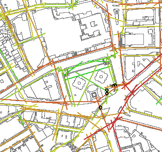
Figure 4 Space Syntax
Computer Model of Trafalgar Square EXISTING
The software
calculates the relative accessibility of each spatial link in the
network and represents the most accessible routes as red lines, then
orange, yellow and green, to the least accessible lines which are blue.
Accessibility is measured by calculating shortest journey routes between
each link and all of the others in the network (defining 'shortest' in
terms of fewest changes of direction).
Visual and statistical
comparison between the Space Syntax analysis of accessibility and the
actual pattern of pedestrian movement in Trafalgar Square shows a high
degree of correspondence. In fact, the computer model successfully
accounts for approximately three-quarters of the actual movement
pattern (Figure 5), doing so even before we consider the effects of other
environmental variables such as local land uses, transport facilities,
building heights, vehicle movements and population densities:
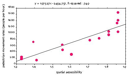
Figure 5 Correspondence
Between Computer Forecast and Actual Movement Rates
In this way,
Space Syntax analysis provides the design team with a powerful tool for
understanding the current pattern of pedestrian activity in Trafalgar
Square, and demonstrating how this pattern is directly related to spatial
design. Having understood current activity, the method can then be used as
a design tool, by simulating design changes and evaluating the effects of
these in terms of pedestrian activity.
Our experience from the
World Squares for All project shows that Space Syntax analysis is also a
design generator, highlighting areas which are either problematic
(such as the change in level between the upper and lower parts of the
Square) or which offer significant design potential (such as the area to
the south of the Square around the statue of King Charles). When the
spatial characteristics of an area have been pinned down, ideas for
solutions begin to emerge in a process we term "evidence based
design".
From Research to Design: Re-engineering the
Square
The findings of the Space Syntax analysis have generated
a number of key redesign ideas for Trafalgar Square. These have been
tabled within the team and evaluated alongside others over the course of
the project. Some of these are illustrated in Figure 6:
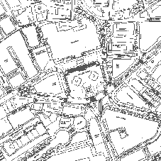
Figure 6 Proposed
Redesign of Trafalgar Square
The redesign proposals
include:
a. the southward extension of the Square and creation of
new, direct pedestrian crossings to the north-west corner of Whitehall and
the north side of Northumberland avenue. The main effects/benefits of this
will be:
b. to expand the area of the Square which will be
naturally used by visitors, decreasing the current congestion in the
south-east corner;
c. to create an area in the Square with stunning
all round views (in contrast to the current restricted views) from which
visitors will take pictures both back into the Square and outwards into
the surrounding urban area
d. to make important views available for
Londoners and visitors alike to assist in orientation and movement. These
include: Whitehall towards the Palace of Westminster; the Mall towards
Buckingham Palace; Northumberland Street towards Hungerford Bridge and
Cockspur Street towards St James'
e. to make the 'centre of London'
a natural and safe destination for visitors to London, thus increasing the
prestige, significance and reputation of the whole Square
f.
opening up the north-east and north-west corner steps into the Square by
the creation of two new flights of steps on diagonal alignments. The main
effects/benefits of the 'diagonal' steps will be:
g. to facilitate
movement across the Square for people living and working in the area, so
that the Square becomes a natural part of their everyday journeys rather
than the obstacle it is at present (currently the orientation of the steps
is a key factor in eliminating natural movement through the Square),
creating naturally used routes which are more pleasant, quicker and less
hazardous than the current difficult routes around the outside
h.
to facilitate movement by visitors to and from the southern parts of the
Square, allowing movement into these areas to approach from different
directions
i. improving the feel of the Square by creating
background movement across the Square in several directions - this being
crucial to the sense that a space is well and naturally used. This will
help generate stationary use within the Square by Londoners as well as
visitors
j. renovation of the upper level space (between the
National Gallery and the existing Square) as an intrinsic part of
Trafalgar Square.
The renovation of this space with its wonderful
viewing potential will require the elimination of all everyday traffic
(allowing occasional access for special visitors to the main entrance of
the National Gallery) from the north side of the Square. However, this on
its own, while essential, will not in itself realise the potential of the
upper level space. This will also require the careful design of this space
and its relation to the main body of the Square, since:
a. movement
will continue to be primarily on the National Gallery side of this space,
and more generous provision will therefore have to be made for this
movement on the north side of the upper level space;
b. the south
side of the upper level space will not (even with the corner steps) be a
significant movement space, but will offer wonderful opportunities for
stationary uses, for people wishing to relax and spend some time in the
Square
c. a direct link between the lower level body of the Square
and upper level part of the space via a new, centrally located stairway.
At present the north, lower level part of the Square and the upper level
space directly above it are the least used areas of the Square. While the
corner steps will create diagonal movement across the Square, they will
not by themselves animate either of these spaces. Nor will
pedestrianisation of the upper north level alone animate the south side of
the upper space. The central link between these two potentially poorly
used spaces will therefore be critical to their mutual animation
by:
d. providing a direct route into the lower level body of the
Square from the National Gallery via the least used part of Trafalgar
Square. Visitors to the Gallery will use this stair whereas they would not
necessarily go into the Square if they had to use the corner steps. These
steps will create a more localised link which will allow 'drift' from one
space to the other, as well as providing a convenient route for people
going directly to and from the Gallery
e. creating a natural
east-west division in the upper level space, with more Londoner-focused
facilities provided on the west side upper level space (where people
working in the area would naturally stop) and more popular facilities on
the east side of the upper level space (where there will be a higher and
more mixed local movement population)
f. and, in general, the
creation of new, well used diagonal routes across the Square for Londoners
which are more pleasant, less time consuming and less hazardous that the
current tortuous routes around the edge of Square.
Each of these
design characteristics has emerged following numerous 'runs' of the
pedestrian computer model. Since processing times are very short (a matter
of seconds) it has been possible to use the computer as a sketchpad for
testing, rejecting and refining design ideas. Analysis of the redesign
proposals indicates the extent to which pedestrian linkages in and around
the Square might be considerably improved (Figure 7).
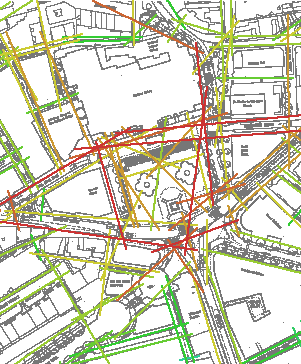
Figure 7 Space Syntax
Computer Model of Trafalgar Square PROPOSED
The Space Syntax
model shows a significant increase in overall levels of pedestrian
accessibility. In particular, new diagonal routes can be seen passing from
one corner of the space to the other, making use of the new corner stairs
and bringing a significantly greater degree of pedestrian activity to the
heart of the space than exists at
present.
SUMMARY
Space Syntax
techniques have been used by the World Squares team to generate and
evaluate a range of design proposals throughout the Study Area. In each
case the needs of pedestrians have been carefully evaluated through
detailed observations of existing activity and spatial modelling of design
possibilities. In this way a masterplan for the area has been developed
which is firmly founded on the results of robust, evidence based
techniques.
|
